
Merrimack River topographic map
Interactive map
Click on the map to display elevation.
About this map
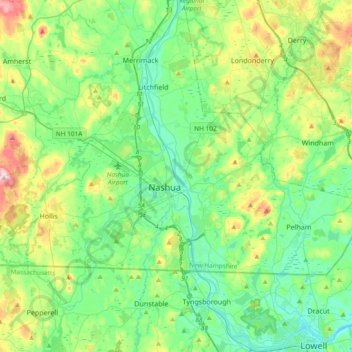
Name: Merrimack River topographic map, elevation, terrain.
Average elevation: 77 m
Minimum elevation: 16 m
Maximum elevation: 246 m
Other topographic maps
Click on a map to view its topography, its elevation and its terrain.
Shipley Hill
United States > New Hampshire > Hillsborough County > Nashua
Shipley Hill, Nashua, Hillsborough County, New Hampshire, 03039, United States
Average elevation: 77 m
Nashua
United States > New Hampshire > Hillsborough County > Nashua
Nashua, Hillsborough County, New Hampshire, 03060-03064, United States
Average elevation: 82 m