
Mühleip topographic map
Interactive map
Click on the map to display elevation.
About this map
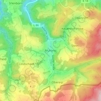
Name: Mühleip topographic map, elevation, terrain.
Average elevation: 225 m
Minimum elevation: 117 m
Maximum elevation: 359 m
Other topographic maps
Click on a map to view its topography, its elevation and its terrain.
Rankenhohn
Deutschland > Nordrhein-Westfalen > Rhein-Sieg-Kreis > Eitorf
Rankenhohn, Eitorf, Rhein-Sieg-Kreis, Nordrhein-Westfalen, 53809, Deutschland
Average elevation: 227 m
Siebigteroth
Deutschland > Nordrhein-Westfalen > Rhein-Sieg-Kreis > Eitorf > Lascheid
Siebigteroth, Lascheid, Eitorf, Rhein-Sieg-Kreis, Nordrhein-Westfalen, 53783, Deutschland
Average elevation: 173 m
Hüppelröttchen
Deutschland > Nordrhein-Westfalen > Rhein-Sieg-Kreis > Eitorf
Hüppelröttchen, Linkenbach, Eitorf, Rhein-Sieg-Kreis, Nordrhein-Westfalen, 53783, Deutschland
Average elevation: 284 m