
Casau topographic map
Interactive map
Click on the map to display elevation.
About this map
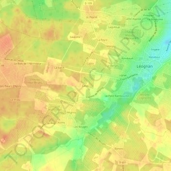
Name: Casau topographic map, elevation, terrain.
Average elevation: 49 m
Minimum elevation: 24 m
Maximum elevation: 61 m
Other topographic maps
Click on a map to view its topography, its elevation and its terrain.
L'Oustalade
France > Nouvelle-Aquitaine > Gironde > Léognan > L'Oustalade
L'Oustalade, Léognan, Bordeaux, Gironde, Nouvelle-Aquitaine, France métropolitaine, 33850, France
Average elevation: 32 m
Le Brûlat
France > Nouvelle-Aquitaine > Gironde > Léognan
Le Brûlat, Léognan, Bordeaux, Gironde, Nouvelle-Aquitaine, France métropolitaine, 33850, France
Average elevation: 44 m
Rataboul
France > Nouvelle-Aquitaine > Gironde > Léognan
Rataboul, Léognan, Bordeaux, Gironde, Nouvelle-Aquitaine, France métropolitaine, 33850, France
Average elevation: 43 m
Luxeau
France > Nouvelle-Aquitaine > Gironde > Léognan
Luxeau, Léognan, Bordeaux, Gironde, Nouvelle-Aquitaine, France métropolitaine, 33850, France
Average elevation: 44 m
Château Belin
France > Nouvelle-Aquitaine > Gironde > Léognan > Lignac
Château Belin, Cours Gambetta, Lignac, Léognan, Bordeaux, Gironde, Nouvelle-Aquitaine, France métropolitaine, 33850, France
Average elevation: 44 m