
La Fromagerie topographic map
Interactive map
Click on the map to display elevation.
About this map
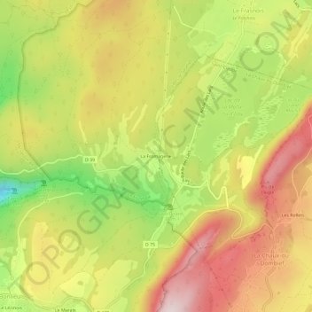
Name: La Fromagerie topographic map, elevation, terrain.
Average elevation: 812 m
Minimum elevation: 550 m
Maximum elevation: 1,034 m
Other topographic maps
Click on a map to view its topography, its elevation and its terrain.
Lac du Vernois
France > Bourgogne-Franche-Comté > Jura > Le Frasnois
Lac du Vernois, Le Frasnois, Lons-le-Saunier, Jura, Bourgogne-Franche-Comté, France métropolitaine, 39130, France
Average elevation: 790 m
Lac de Narlay
France > Bourgogne-Franche-Comté > Jura > Le Frasnois
Lac de Narlay, Le Frasnois, Lons-le-Saunier, Jura, Bourgogne-Franche-Comté, France métropolitaine, 39130, France
Average elevation: 810 m