
Meylan topographic map
Interactive map
Click on the map to display elevation.
About this map
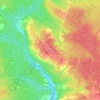
Name: Meylan topographic map, elevation, terrain.
Average elevation: 125 m
Minimum elevation: 80 m
Maximum elevation: 162 m
Other topographic maps
Click on a map to view its topography, its elevation and its terrain.
Meylan
France > Nouvelle-Aquitaine > Lot-et-Garonne > Sos
Meylan, Sos, Nérac, Lot-et-Garonne, Nouvelle-Aquitaine, France métropolitaine, 47170, France
Average elevation: 128 m
Gueyze
France > Nouvelle-Aquitaine > Lot-et-Garonne > Sos
Gueyze, Sos, Nérac, Lot-et-Garonne, Nouvelle-Aquitaine, France métropolitaine, 47170, France
Average elevation: 128 m
Gueyze
France > Nouvelle-Aquitaine > Lot-et-Garonne > Sos
Gueyze, Sos, Nérac, Lot-et-Garonne, Nouvelle-Aquitaine, France métropolitaine, 47170, France
Average elevation: 119 m