
Thank you for supporting this site ❤️
Make a donation
Make a donation
Upper Savoy topographic map
Click on the map to display elevation.
Thank you for supporting this site ❤️
Make a donation
Make a donation
Upper Savoy
Haute-Savoie has the largest range of elevations of all the departments in France; the lowest point is 250 metres (820 ft) in the Rhône Valley, and the highest Mont Blanc at 4,810.40 metres (15,782.2 ft). Some of the world's best-known ski resorts are in Haute-Savoie.
Thank you for supporting this site ❤️
Make a donation
Make a donation
About this map
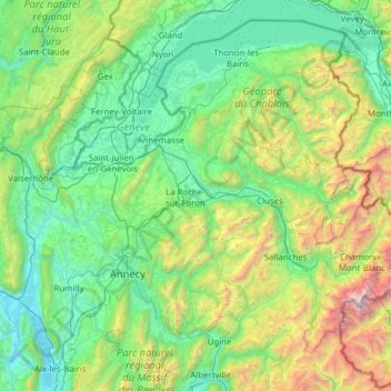
Name: Upper Savoy topographic map, elevation, terrain.
Location: Upper Savoy, Auvergne-Rhône-Alpes, Metropolitan France, France (45.68171 5.80513 46.45637 7.04529)
Average elevation: 1,032 m
Minimum elevation: 225 m
Maximum elevation: 4,728 m
Thank you for supporting this site ❤️
Make a donation
Make a donation
Other topographic maps
Click on a map to view its topography, its elevation and its terrain.