
Thank you for supporting this site ❤️
Make a donation
Make a donation
Rother topographic map
Click on the map to display elevation.
Thank you for supporting this site ❤️
Make a donation
Make a donation
About this map
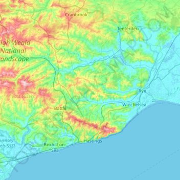
Name: Rother topographic map, elevation, terrain.
Location: Rother, East Sussex, England, United Kingdom (50.81919 0.32156 51.08365 0.86786)
Average elevation: 36 m
Minimum elevation: -2 m
Maximum elevation: 194 m
Thank you for supporting this site ❤️
Make a donation
Make a donation