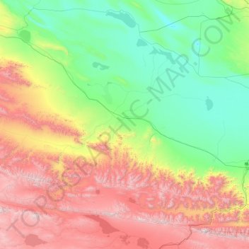
ཨུར་ཏུ་མོ་རོན 乌图美仁乡 topographic map
Interactive map
Click on the map to display elevation.
About this map
Name: ཨུར་ཏུ་མོ་རོན 乌图美仁乡 topographic map, elevation, terrain.
Average elevation: 3,555 m
Minimum elevation: 2,654 m
Maximum elevation: 5,926 m

Click on the map to display elevation.
Name: ཨུར་ཏུ་མོ་རོན 乌图美仁乡 topographic map, elevation, terrain.
Average elevation: 3,555 m
Minimum elevation: 2,654 m
Maximum elevation: 5,926 m