
Make a donation
Wiernsheim topographic map
Click on the map to display elevation.
Make a donation
Wiernsheim
The municipality (Gemeinde) of Wiernsheim covers 24.62 kilometers (15.30 mi) of the Enzkreis, a district of the state of Baden-Württemberg and the Federal Republic of Germany. It is located in the metropolitan areas of Karlsruhe and Pforzheim, along the southwestern edge of the Neckar basin [de]. Wiernsheim is physically in the Heckengäu, a region characterized by wooded and karstified hills of muschelkalk. Elevation above sea level in municipal area ranges from a low of 274 meters (899 ft) Normalnull (NN) on the Kreuzbach and a high of 464 meters (1,522 ft) NN in the southwest.
Make a donation
About this map
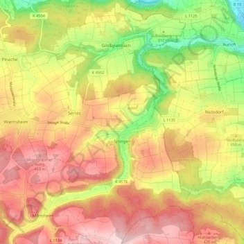
Name: Wiernsheim topographic map, elevation, terrain.
Average elevation: 358 m
Minimum elevation: 202 m
Maximum elevation: 482 m
Make a donation
Other topographic maps
Click on a map to view its topography, its elevation and its terrain.
Holzbachtal
Germany > Baden-Württemberg > Enzkreis > Straubenhardt > Langenalb
Average elevation: 449 m
Make a donation