
Ommersheim topographic map
Interactive map
Click on the map to display elevation.
About this map
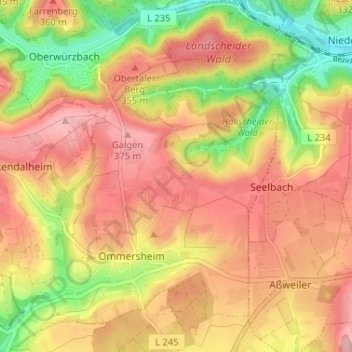
Name: Ommersheim topographic map, elevation, terrain.
Average elevation: 320 m
Minimum elevation: 228 m
Maximum elevation: 385 m
Other topographic maps
Click on a map to view its topography, its elevation and its terrain.
Gräfinthal
Deutschland > Saarland > Saarpfalz-Kreis > Mandelbachtal
Gräfinthal, Bliesmengen-Bolchen, Mandelbachtal, Saarpfalz-Kreis, Saarland, 66399, Deutschland
Average elevation: 299 m
Habkirchen
Deutschland > Saarland > Saarpfalz-Kreis > Mandelbachtal
Habkirchen, Mandelbachtal, Saarpfalz-Kreis, Saarland, Deutschland
Average elevation: 267 m