
Town of Namakagon topographic map
Interactive map
Click on the map to display elevation.
About this map
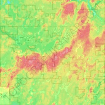
Name: Town of Namakagon topographic map, elevation, terrain.
Location: Town of Namakagon, Bayfield County, Wisconsin, United States (46.15460 -91.17635 46.24250 -90.92410)
Average elevation: 443 m
Minimum elevation: 404 m
Maximum elevation: 496 m
Other topographic maps
Click on a map to view its topography, its elevation and its terrain.
Raspberry Island
United States > Wisconsin > Bayfield County
Raspberry Island, Town of Russell, Bayfield County, Wisconsin, United States
Average elevation: 182 m
Houghton Point
United States > Wisconsin > Bayfield County
Houghton Point, Town of Bayview, Bayfield County, Wisconsin, United States
Average elevation: 192 m
Town of Kelly
United States > Wisconsin > Bayfield County
Town of Kelly, Bayfield County, Wisconsin, United States
Average elevation: 281 m
Sand Bay
United States > Wisconsin > Bayfield County > Sand Bay
Sand Bay, Town of Russell, Bayfield County, Wisconsin, United States
Average elevation: 209 m