
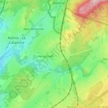
Hergenrath topographic map
Interactive map
Click on the map to display elevation.
About this map
Name: Hergenrath topographic map, elevation, terrain.
Average elevation: 237 m
Minimum elevation: 170 m
Maximum elevation: 366 m
Other topographic maps
Click on a map to view its topography, its elevation and its terrain.
Eyneburg
Belgique > Liège > Verviers > La Calamine > Hergenrath
Eyneburg, 24;26, Chemin d'Emmaburg, Hergenrath, La Calamine, Verviers, Liège, Wallonie, 4728, Belgique
Average elevation: 216 m