
Thank you for supporting this site ❤️
Make a donation
Make a donation
Municipio Entre Ríos topographic map
Click on the map to display elevation.
Thank you for supporting this site ❤️
Make a donation
Make a donation
About this map
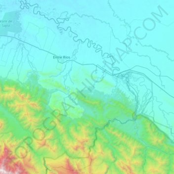
Name: Municipio Entre Ríos topographic map, elevation, terrain.
Location: Municipio Entre Ríos, Cochabamba, CBB, Bolivia (-17.61095 -64.90568 -17.00003 -64.24374)
Average elevation: 548 m
Minimum elevation: 189 m
Maximum elevation: 3,372 m
Thank you for supporting this site ❤️
Make a donation
Make a donation
Other topographic maps
Click on a map to view its topography, its elevation and its terrain.