
Lake Placid topographic map
Interactive map
Click on the map to display elevation.
About this map
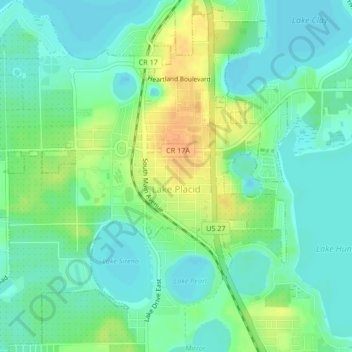
Name: Lake Placid topographic map, elevation, terrain.
Location: Lake Placid, Highlands County, Florida, 33852, United States (27.27582 -81.39029 27.31301 -81.34960)
Average elevation: 32 m
Minimum elevation: 20 m
Maximum elevation: 53 m
Other topographic maps
Click on a map to view its topography, its elevation and its terrain.
Sebring
United States > Florida > Highlands County
Sebring, Highlands County, Florida, 33870, United States
Average elevation: 34 m
Lake Huntley
United States > Florida > Highlands County
Lake Huntley, Highlands County, Florida, United States
Average elevation: 30 m
Avon Park
United States > Florida > Highlands County
Avon Park, Highlands County, Florida, 33825, United States
Average elevation: 43 m
Placid Lakes
United States > Florida > Highlands County
Placid Lakes, Highlands County, Florida, United States, Lake August
Average elevation: 34 m
Placid Lakes
United States > Florida > Highlands County
Placid Lakes, Highlands County, Florida, United States
Average elevation: 33 m
Lake Istokpoga
United States > Florida > Highlands County
Lake Istokpoga, Highlands County, Florida, United States
Average elevation: 15 m
Sebring
United States > Florida > Highlands County > Sebring
Sebring, Highlands County, Florida, 33871, United States
Average elevation: 36 m
Venus
United States > Florida > Highlands County
Venus, Highlands County, Florida, 33960, United States
Average elevation: 33 m
Kuhlman
United States > Florida > Highlands County > Kuhlman
Kuhlman, Highlands County, Florida, 33872:33875, United States
Average elevation: 29 m