
Tooele topographic map
Click on the map to display elevation.
About this map
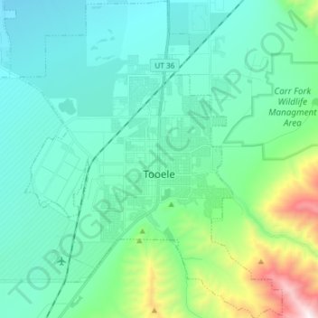
Name: Tooele topographic map, elevation, terrain.
Location: Tooele, Tooele County, Utah, United States (40.48018 -112.36311 40.59201 -112.24131)
Average elevation: 1,610 m
Minimum elevation: 1,328 m
Maximum elevation: 2,854 m
Other topographic maps
Click on a map to view its topography, its elevation and its terrain.
Deseret Peak
United States > Utah > Tooele County
Deseret Peak is the highest peak in the Stansbury Mountains with an elevation of 11,035 ft. It is located in the Deseret Peak Wilderness area west of Grantsville, Utah and east of Skull Valley Indian Reservation. It is the fourth most topographically prominent peak in the state of Utah. The site is a popular…
Average elevation: 2,910 m