
Zion National Park topographic map
Interactive map
Click on the map to display elevation.
Zion National Park
The 8,726-foot (2,660 m) summit of Horse Ranch Mountain is the highest point in the park; the lowest point is the 3,666-foot (1,117 m) elevation of Coal Pits Wash, creating a relief of about 5,100 feet (1,600 m).
About this map
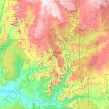
Name: Zion National Park topographic map, elevation, terrain.
Location: Zion National Park, Washington County, Utah, United States (37.14135 -113.22829 37.50429 -112.86315)
Average elevation: 1,877 m
Minimum elevation: 1,055 m
Maximum elevation: 2,876 m