
Thank you for supporting this site ❤️
Make a donation
Make a donation
Höfgen topographic map
Click on the map to display elevation.
Thank you for supporting this site ❤️
Make a donation
Make a donation
About this map
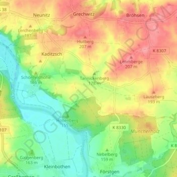
Name: Höfgen topographic map, elevation, terrain.
Location: Höfgen, Grimma, Landkreis Leipzig, Sachsen, Deutschland (51.19801 12.74455 51.22262 12.81662)
Average elevation: 167 m
Minimum elevation: 125 m
Maximum elevation: 211 m
Thank you for supporting this site ❤️
Make a donation
Make a donation
Other topographic maps
Click on a map to view its topography, its elevation and its terrain.
Thank you for supporting this site ❤️
Make a donation
Make a donation
Thank you for supporting this site ❤️
Make a donation
Make a donation
Mutzschen
Deutschland > Sachsen > Landkreis Leipzig > Grimma
Die Erwähnung des quarum prima Musitscin kann hinweisen auf die mysbcani, das sind die Leute auf der kleinen hervorragenden Höhe, welche von einem Wasser umflossen wird. Die heutige Bezeichnung Mutzschener Wasser ist ein Hinweis auf den verschwundenen Fluss Orechnovna, der dem Muldesystem zuzuordnen war.…
Average elevation: 186 m
Thank you for supporting this site ❤️
Make a donation
Make a donation