
Kaous topographic map
Interactive map
Click on the map to display elevation.
About this map
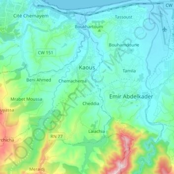
Name: Kaous topographic map, elevation, terrain.
Location: Kaous, Daïra Texenna, Jijel, Algérie (36.71729 5.69517 36.79781 5.83272)
Average elevation: 128 m
Minimum elevation: -1 m
Maximum elevation: 680 m
Other topographic maps
Click on a map to view its topography, its elevation and its terrain.
Texenna
Algérie > Jijel > Daïra Texenna
Texenna, Daïra Texenna, Jijel, Algérie
Average elevation: 526 m