
Río Luján topographic map
Interactive map
Click on the map to display elevation.
About this map
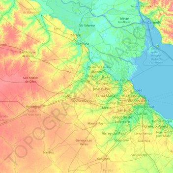
Name: Río Luján topographic map, elevation, terrain.
Average elevation: 23 m
Minimum elevation: -3 m
Maximum elevation: 70 m
Other topographic maps
Click on a map to view its topography, its elevation and its terrain.
Reserva Natural del Pilar
Argentina > Buenos Aires > Pilar
Reserva Natural del Pilar, General Manuel Savio, Villa Morra, Pilar, Partido del Pilar, Buenos Aires, 1629, Argentina
Average elevation: 7 m
Sendero de las Tortugas
Argentina > Buenos Aires > Pilar
Sendero de las Tortugas, Arboretum, Villa Morra, Pilar, Partido del Pilar, Buenos Aires, 1629, Argentina
Average elevation: 7 m