
Mengwi topographic map
Interactive map
Click on the map to display elevation.
About this map
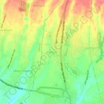
Name: Mengwi topographic map, elevation, terrain.
Location: Mengwi, Badung, Bali, 08351, Indonesien (-8.56663 115.14650 -8.52663 115.18650)
Average elevation: 123 m
Minimum elevation: 88 m
Maximum elevation: 159 m
Other topographic maps
Click on a map to view its topography, its elevation and its terrain.