
Daïra Rouiba topographic map
Interactive map
Click on the map to display elevation.
About this map
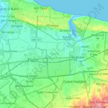
Name: Daïra Rouiba topographic map, elevation, terrain.
Location: Daïra Rouiba, Alger, RADP (36.69786 3.23863 36.78638 3.38258)
Average elevation: 27 m
Minimum elevation: -3 m
Maximum elevation: 117 m
Other topographic maps
Click on a map to view its topography, its elevation and its terrain.
Oued Koreiche
RADP > Alger > Oued Koreiche
Oued Koreiche, Daïra Bab El Oued, Alger, RADP
Average elevation: 144 m