
Thank you for supporting this site ❤️
Make a donation
Make a donation
Brynithel topographic map
Click on the map to display elevation.
Thank you for supporting this site ❤️
Make a donation
Make a donation
About this map
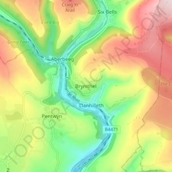
Name: Brynithel topographic map, elevation, terrain.
Location: Brynithel, Blaenau Gwent, Wales, NP13 2HN, United Kingdom (51.68485 -3.15675 51.72485 -3.11675)
Average elevation: 288 m
Minimum elevation: 127 m
Maximum elevation: 485 m
Thank you for supporting this site ❤️
Make a donation
Make a donation
Other topographic maps
Click on a map to view its topography, its elevation and its terrain.