
Ymittos topographic map
Interactive map
Click on the map to display elevation.
About this map
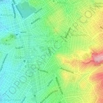
Name: Ymittos topographic map, elevation, terrain.
Average elevation: 129 m
Minimum elevation: 70 m
Maximum elevation: 238 m
Other topographic maps
Click on a map to view its topography, its elevation and its terrain.
Athen
Griechenland > Attika > Regionalbezirk Athen-Zentrum
Athen, Δήμος Αθηναίων, Regionalbezirk Athen-Zentrum, Region Attika, Attika, 105 57, Griechenland
Average elevation: 168 m