
Chebcheb topographic map
Interactive map
Click on the map to display elevation.
About this map
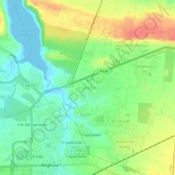
Name: Chebcheb topographic map, elevation, terrain.
Location: Chebcheb, Reghaïa, Daïra Rouiba, Alger, 16036, Algérie (36.73646 3.33296 36.77646 3.37296)
Average elevation: 24 m
Minimum elevation: -4 m
Maximum elevation: 59 m
Other topographic maps
Click on a map to view its topography, its elevation and its terrain.
Djaâfri
Algérie > Alger > Daïra Rouiba > Reghaïa
Djaâfri, Reghaïa, Daïra Rouiba, Alger, 16036, Algérie
Average elevation: 23 m