
La Charagne topographic map
Interactive map
Click on the map to display elevation.
About this map
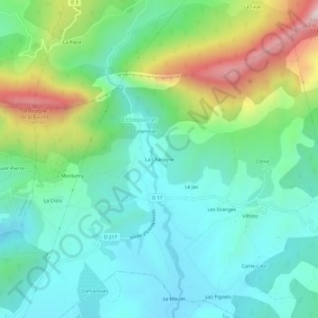
Name: La Charagne topographic map, elevation, terrain.
Average elevation: 703 m
Minimum elevation: 513 m
Maximum elevation: 1,197 m
Other topographic maps
Click on a map to view its topography, its elevation and its terrain.
Les Naux
France > Provence-Alpes-Côte d'Azur > Alpes-de-Haute-Provence > Entrepierres > Les Naux
Les Naux, Entrepierres, Forcalquier, Alpes-de-Haute-Provence, Provence-Alpes-Côte d'Azur, France métropolitaine, 04200, France
Average elevation: 990 m
Les Pignets
France > Provence-Alpes-Côte d'Azur > Alpes-de-Haute-Provence > Entrepierres
Les Pignets, Entrepierres, Forcalquier, Alpes-de-Haute-Provence, Provence-Alpes-Côte d'Azur, France métropolitaine, 04200, France
Average elevation: 590 m
Méhane
France > Provence-Alpes-Côte d'Azur > Alpes-de-Haute-Provence > Entrepierres
Méhane, Entrepierres, Forcalquier, Alpes-de-Haute-Provence, Provence-Alpes-Côte d'Azur, France métropolitaine, 04200, France
Average elevation: 701 m
Roman
France > Provence-Alpes-Côte d'Azur > Alpes-de-Haute-Provence > Entrepierres
Roman, Entrepierres, Forcalquier, Alpes-de-Haute-Provence, Provence-Alpes-Côte d'Azur, France métropolitaine, 04200, France
Average elevation: 997 m