
Le Grand Bourguel topographic map
Interactive map
Click on the map to display elevation.
About this map
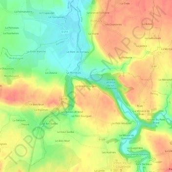
Name: Le Grand Bourguel topographic map, elevation, terrain.
Average elevation: 56 m
Minimum elevation: 17 m
Maximum elevation: 92 m
Other topographic maps
Click on a map to view its topography, its elevation and its terrain.
La Vallée du Pont
France > Bretagne > Ille-et-Vilaine > Vieux-Vy-sur-Couesnon
La Vallée du Pont, Vieux-Vy-sur-Couesnon, Rennes, Ille-et-Vilaine, Bretagne, France métropolitaine, 35490, France
Average elevation: 68 m