
Thank you for supporting this site ❤️
Make a donation
Make a donation
Meru County topographic map
Click on the map to display elevation.
Thank you for supporting this site ❤️
Make a donation
Make a donation
Meru County
Agriculture is the main economic activity due to rich Volcanic soils in high altitude areas.Meru County is the leading County in Kenya by Horticultural productionCoffee, tea, French-beans and dairy products as primary produce. Wholesale and retail trade also play important role in the county's economy. It's the Leading County that produces Miraa (Khat) for export and hence boosting the economic national grid.
Thank you for supporting this site ❤️
Make a donation
Make a donation
About this map
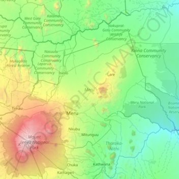
Name: Meru County topographic map, elevation, terrain.
Location: Meru County, Eastern, Kenya (-0.21547 37.09070 0.66863 38.42083)
Average elevation: 1,212 m
Minimum elevation: 336 m
Maximum elevation: 4,996 m
Thank you for supporting this site ❤️
Make a donation
Make a donation
Other topographic maps
Click on a map to view its topography, its elevation and its terrain.