
Passais-Villages topographic map
Interactive map
Click on the map to display elevation.
About this map
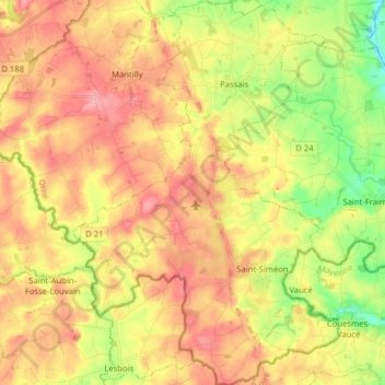
Name: Passais-Villages topographic map, elevation, terrain.
Average elevation: 174 m
Minimum elevation: 116 m
Maximum elevation: 222 m
Other topographic maps
Click on a map to view its topography, its elevation and its terrain.
Mesnil Boissy
France > Normandie > Orne > Passais-Villages > Passais
Mesnil Boissy, Passais, Passais-Villages, Alençon, Orne, Normandie, France métropolitaine, 61350, France
Average elevation: 172 m
Passais
France > Normandie > Orne > Passais-Villages
Passais, Passais-Villages, Alençon, Orne, Normandie, France métropolitaine, 61350, France
Average elevation: 171 m