
Plaka topographic map
Interactive map
Click on the map to display elevation.
About this map
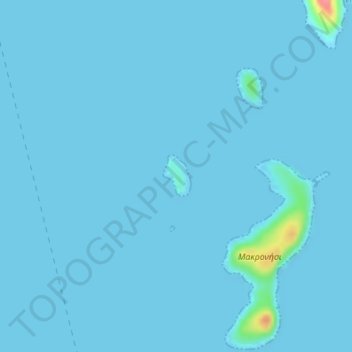
Name: Plaka topographic map, elevation, terrain.
Average elevation: 2 m
Minimum elevation: 0 m
Maximum elevation: 76 m
Other topographic maps
Click on a map to view its topography, its elevation and its terrain.
Ikaria
Griechenland > Ägäis > Regionalbezirk Ikaria
Ikaria, Regionalbezirk Ikaria, Region Nördliche Ägäis, Ägäis, Griechenland
Average elevation: 87 m