
Merlau topographic map
Interactive map
Click on the map to display elevation.
About this map
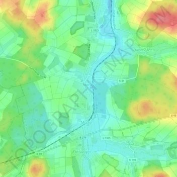
Name: Merlau topographic map, elevation, terrain.
Location: Merlau, Mücke, Vogelsbergkreis, Hessen, 35325, Deutschland (50.61052 9.00351 50.63606 9.06333)
Average elevation: 288 m
Minimum elevation: 260 m
Maximum elevation: 341 m
Die Statistisch-topographisch-historische Beschreibung des Großherzogthums Hessen berichtet 1830 über Merlau: