Harlan topographic map
Interactive map
Click on the map to display elevation.
About this map
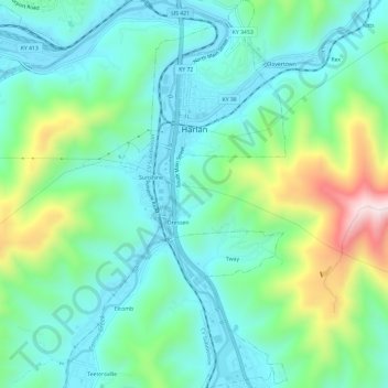
Name: Harlan topographic map, elevation, terrain.
Location: Harlan, Harlan County, Kentucky, 40831, United States (36.81142 -83.33322 36.85899 -83.30762)
Average elevation: 493 m
Minimum elevation: 350 m
Maximum elevation: 910 m
Harlan is located in west-central Harlan County at 36°50′29″N 83°19′12″W / 36.84139°N 83.32000°W / 36.84139; -83.32000 (36.841487, -83.320066), at the junction of the Clover Fork and Martin's Fork rivers. The Clover Fork continues north 1.5 miles (2.4 km) to join the Poor Fork, forming the Cumberland River, a major tributary of the Ohio River. Harlan is in a narrow mountain valley, constrained to the north by the western end of Black Mountain, to the south by Little Black Mountain, and to the west by Ewing Spur. The elevation at the Harlan Courthouse is 1,197 feet (365 m) above sea level, while the surrounding ridges rise outside the city limits to 2,100 feet (640 m) (Black Mountain), 3,000 feet (910 m) (Little Black Mountain), and 2,300 feet (700 m) (Ewing Spur).
Other topographic maps
Click on a map to view its topography, its elevation and its terrain.
Pathfork
United States > Kentucky > Harlan County
Pathfork, Harlan County, Kentucky, 40863, United States
Average elevation: 534 m
Lenarue
United States > Kentucky > Harlan County
Lenarue, Harlan County, Kentucky, 40818, United States
Average elevation: 519 m
Bardo
United States > Kentucky > Harlan County
Bardo, Harlan County, Kentucky, 40830, United States
Average elevation: 634 m
Holmes Mill
United States > Kentucky > Harlan County
Holmes Mill, Harlan County, Kentucky, 40843, United States
Average elevation: 758 m
Pansy
United States > Kentucky > Harlan County
Pansy, Harlan County, Kentucky, 40830, United States
Average elevation: 602 m
Putney
United States > Kentucky > Harlan County
Putney, Harlan County, Kentucky, 40865, United States
Average elevation: 601 m
Alva
United States > Kentucky > Harlan County
Alva, Harlan County, Kentucky, 40863, United States
Average elevation: 652 m
Yancey
United States > Kentucky > Harlan County
Yancey, Harlan County, Kentucky, 40830, United States
Average elevation: 651 m
Fresh Meadows
United States > Kentucky > Harlan County
Fresh Meadows, Harlan County, Kentucky, 40824, United States
Average elevation: 462 m
Pine Mountain
United States > Kentucky > Harlan County
Pine Mountain, Harlan County, Kentucky, United States
Average elevation: 536 m
Kenvir
United States > Kentucky > Harlan County
Kenvir, Harlan County, Kentucky, 40847, United States
Average elevation: 642 m
Ages
United States > Kentucky > Harlan County
Ages, Harlan County, Kentucky, 40801, United States
Average elevation: 587 m
Wallins Creek
United States > Kentucky > Harlan County
Wallins Creek, Harlan County, Kentucky, United States
Average elevation: 416 m
Lejunior
United States > Kentucky > Harlan County
Lejunior, Harlan County, Kentucky, 40865, United States
Average elevation: 585 m
Three Point
United States > Kentucky > Harlan County
Three Point, Harlan County, Kentucky, 40815, United States
Average elevation: 475 m
Louellen
United States > Kentucky > Harlan County
Louellen, Harlan County, Kentucky, 40849, United States
Average elevation: 698 m
Big Laurel
United States > Kentucky > Harlan County
Big Laurel, Harlan County, Kentucky, 40808, United States
Average elevation: 574 m
Cawood
United States > Kentucky > Harlan County
Cawood, Harlan County, Kentucky, 40818, United States
Average elevation: 498 m
South Wallins
United States > Kentucky > Harlan County > South Wallins
South Wallins, Harlan County, Kentucky, 40873, United States
Average elevation: 528 m
Dayhoit
United States > Kentucky > Harlan County
Dayhoit, Harlan County, Kentucky, 40824, United States
Average elevation: 462 m
Loyall
United States > Kentucky > Harlan County
Loyall, Harlan County, Kentucky, 40854, United States
Average elevation: 434 m
Molus
United States > Kentucky > Harlan County
Molus, Harlan County, Kentucky, 40819, United States
Average elevation: 467 m
Closplint
United States > Kentucky > Harlan County
Closplint, Harlan County, Kentucky, 40927, United States
Average elevation: 716 m
Benham
United States > Kentucky > Harlan County
Benham, Harlan County, Kentucky, 40807, United States
Average elevation: 667 m
Totz
United States > Kentucky > Harlan County
Totz, Harlan County, Kentucky, 40870, United States
Average elevation: 638 m
Bledsoe
United States > Kentucky > Harlan County
Bledsoe, Harlan County, Kentucky, 40810, United States
Average elevation: 604 m
Creech
United States > Kentucky > Harlan County
Creech, Harlan County, Kentucky, United States
Average elevation: 661 m
River Ridge
United States > Kentucky > Harlan County
River Ridge, Harlan County, Kentucky, 40828, United States
Average elevation: 584 m
Evarts
United States > Kentucky > Harlan County
Evarts, Harlan County, Kentucky, United States
Average elevation: 533 m
Baxter
United States > Kentucky > Harlan County
Baxter, Harlan County, Kentucky, 40806, United States
Average elevation: 468 m
Coldiron
United States > Kentucky > Harlan County
Coldiron, Harlan County, Kentucky, 40819, United States
Average elevation: 472 m
Lynch
United States > Kentucky > Harlan County
Lynch, Harlan County, Kentucky, United States
Average elevation: 770 m
Divide
United States > Kentucky > Harlan County
Divide, Harlan County, Kentucky, 40865, United States
Average elevation: 657 m
Cranks
United States > Kentucky > Harlan County
Cranks, Harlan County, Kentucky, 40820, United States
Average elevation: 594 m
Harlan
United States > Kentucky > Harlan County > Harlan > Harlan
Harlan, Harlan County, Kentucky, 40831, United States
Average elevation: 512 m
Cumberland
United States > Kentucky > Harlan County
Cumberland, Harlan County, Kentucky, 40823, United States
Average elevation: 591 m