
Make a donation
Portimão topographic map
Click on the map to display elevation.
Make a donation
Portimão
The geographical distribution of the altitude and relief of the municipality of Portimão generically follow the three types of territory present in the Barlavento: the coastal region, the Barrocal (a region between the coastal region and the mountains) and the mountains up north. Each one with their own geological, morphological and pedagogical characteristics.
Make a donation
About this map
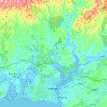
Name: Portimão topographic map, elevation, terrain.
Location: Portimão, Faro, Portugal (37.10842 -8.68466 37.27992 -8.48520)
Average elevation: 67 m
Minimum elevation: -8 m
Maximum elevation: 332 m
Make a donation
Other topographic maps
Click on a map to view its topography, its elevation and its terrain.
Barão de São João
Portugal > Faro > Bensafrim e Barão de São João > Barão de São João
Average elevation: 88 m