
Richmond City topographic map
Interactive map
Click on the map to display elevation.
About this map
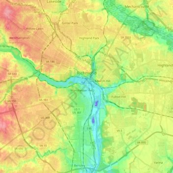
Name: Richmond City topographic map, elevation, terrain.
Location: Richmond City, Virginia, USA (37.44673 -77.60117 37.60245 -77.38530)
Average elevation: 49 m
Minimum elevation: -44 m
Maximum elevation: 104 m
Other topographic maps
Click on a map to view its topography, its elevation and its terrain.
Bush Mountain
USA > Virginia > Harrisonburg
Bush Mountain, Harrisonburg, Rockingham County, Virginia, USA
Average elevation: 634 m
James River
James River, Henrico County, Virginia, 23219:23223, USA
Average elevation: 89 m