
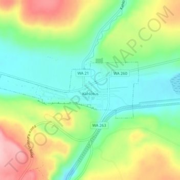
Kahlotus topographic map
Interactive map
Click on the map to display elevation.
About this map
Name: Kahlotus topographic map, elevation, terrain.
Average elevation: 327 m
Minimum elevation: 259 m
Maximum elevation: 433 m
Being located on the floor of a coulee puts Kahlotus at relatively lower elevation than the surrounding terrain. The steep walls of the coulee rise hundreds of feet dramatically to the north and south of the city center.
Other topographic maps
Click on a map to view its topography, its elevation and its terrain.
Farrington
United States > Washington > Franklin County
Farrington, Franklin County, Washington, United States
Average elevation: 294 m
Harder
United States > Washington > Franklin County
Harder, Franklin County, Washington, United States
Average elevation: 350 m
West Pasco
United States > Washington > Franklin County
West Pasco, Franklin County, Washington, United States
Average elevation: 119 m
Lower Monumental Dam
United States > Washington > Franklin County
Lower Monumental Dam, Franklin County, Washington, United States
Average elevation: 230 m
Basin City
United States > Washington > Franklin County
Basin City, Franklin County, Washington, 99343, United States
Average elevation: 221 m
Connell
United States > Washington > Franklin County
Connell, Franklin County, Washington, 99326, United States
Average elevation: 312 m
Mesa
United States > Washington > Franklin County
Mesa, Franklin County, Washington, United States
Average elevation: 239 m
Eltopia
United States > Washington > Franklin County
Eltopia, Franklin County, Washington, United States
Average elevation: 211 m
Pasco
United States > Washington > Franklin County
Pasco, Franklin County, Washington, 99301, United States
Average elevation: 141 m
Pasco
United States > Washington > Franklin County > Pasco
Pasco, Franklin County, Washington, United States
Average elevation: 165 m