
Δήμος Κηφισιάς topographic map
Interactive map
Click on the map to display elevation.
About this map
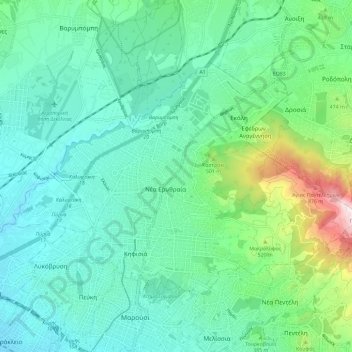
Name: Δήμος Κηφισιάς topographic map, elevation, terrain.
Average elevation: 342 m
Minimum elevation: 154 m
Maximum elevation: 1,031 m
Other topographic maps
Click on a map to view its topography, its elevation and its terrain.
Marousi
Griechenland > Attika > Regionalbezirk Athen-Nord
Marousi, Δήμος Αμαρουσίου, Regionalbezirk Athen-Nord, Region Attika, Attika, 151 24, Griechenland
Average elevation: 257 m
Δήμος Νέας Ιωνίας
Griechenland > Attika > Regionalbezirk Athen-Nord
Δήμος Νέας Ιωνίας, Regionalbezirk Athen-Nord, Region Attika, Attika, Griechenland
Average elevation: 147 m