
Thank you for supporting this site ❤️
Make a donation
Make a donation
Aisemont topographic map
Click on the map to display elevation.
Thank you for supporting this site ❤️
Make a donation
Make a donation
About this map
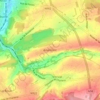
Name: Aisemont topographic map, elevation, terrain.
Location: Aisemont, Fosses-la-Ville, Namen, Wallonië, 5070, België (50.38486 4.63132 50.42486 4.67132)
Average elevation: 175 m
Minimum elevation: 100 m
Maximum elevation: 240 m
Thank you for supporting this site ❤️
Make a donation
Make a donation
Other topographic maps
Click on a map to view its topography, its elevation and its terrain.