
Thank you for supporting this site ❤️
Make a donation
Make a donation
Crato topographic map
Click on the map to display elevation.
Thank you for supporting this site ❤️
Make a donation
Make a donation
About this map
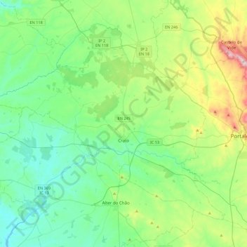
Name: Crato topographic map, elevation, terrain.
Location: Crato, Portalegre, Portugal (39.17736 -7.90128 39.43877 -7.46711)
Average elevation: 287 m
Minimum elevation: 124 m
Maximum elevation: 805 m
Thank you for supporting this site ❤️
Make a donation
Make a donation
Other topographic maps
Click on a map to view its topography, its elevation and its terrain.
Relva da Asseiceira
Portugal > Portalegre > Marvão > Santo António das Areias
Average elevation: 482 m
Thank you for supporting this site ❤️
Make a donation
Make a donation
Thank you for supporting this site ❤️
Make a donation
Make a donation