
Thank you for supporting this site ❤️
Make a donation
Make a donation
Parnamirim topographic map
Click on the map to display elevation.
Thank you for supporting this site ❤️
Make a donation
Make a donation
Parnamirim
Parnamirim belongs to the Intermediate Geographic Region of Natal and the Metropolitan Region of Natal. It is located on the coast with Atlantic Ocean, about 13 kilometers south of the urban center of Natal. Its average elevation is 48 meters above the sea level.
Thank you for supporting this site ❤️
Make a donation
Make a donation
About this map
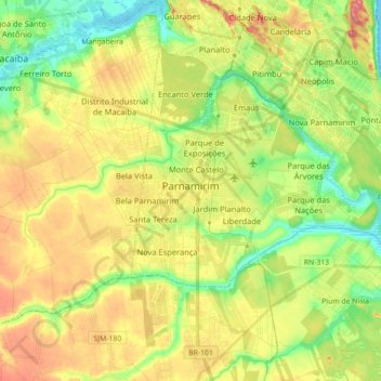
Name: Parnamirim topographic map, elevation, terrain.
Average elevation: 48 m
Minimum elevation: 0 m
Maximum elevation: 107 m
Thank you for supporting this site ❤️
Make a donation
Make a donation