
La Cracousserie topographic map
Interactive map
Click on the map to display elevation.
About this map
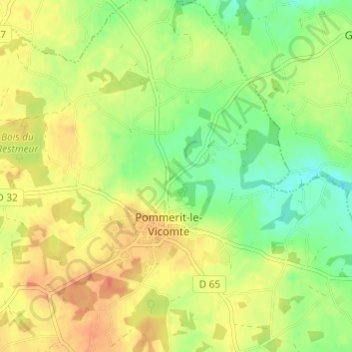
Name: La Cracousserie topographic map, elevation, terrain.
Average elevation: 91 m
Minimum elevation: 69 m
Maximum elevation: 111 m
Other topographic maps
Click on a map to view its topography, its elevation and its terrain.
Saint-Jérôme
France > Bretagne > Côtes-d'Armor > Pommerit-le-Vicomte > Saint-Jérôme
Saint-Jérôme, Pommerit-le-Vicomte, Guingamp, Côtes-d'Armor, Bretagne, France métropolitaine, 22200, France
Average elevation: 86 m
Pouldu
France > Bretagne > Côtes-d'Armor > Pommerit-le-Vicomte > Pouldu
Pouldu, Pommerit-le-Vicomte, Guingamp, Côtes-d'Armor, Bretagne, France métropolitaine, 22200, France
Average elevation: 90 m