
El Hamdania topographic map
Interactive map
Click on the map to display elevation.
About this map
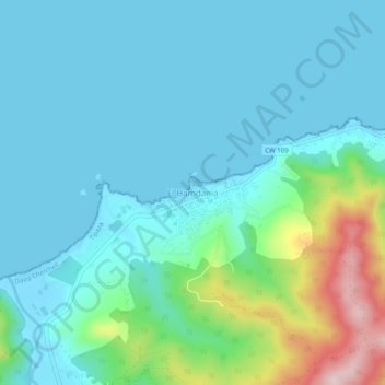
Name: El Hamdania topographic map, elevation, terrain.
Location: El Hamdania, Cherchell, Daïra Cherchell, Tipaza, Algérie (36.60685 2.25344 36.64685 2.29344)
Average elevation: 59 m
Minimum elevation: -6 m
Maximum elevation: 316 m
Other topographic maps
Click on a map to view its topography, its elevation and its terrain.
3 ilots
Algérie > Tipaza > Daïra Cherchell > Cherchell > El Hamdania
3 ilots, El Hamdania, Cherchell, Daïra Cherchell, Tipaza, Algérie
Average elevation: 28 m