
Keraël topographic map
Interactive map
Click on the map to display elevation.
About this map
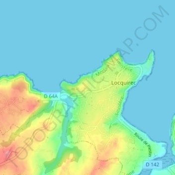
Name: Keraël topographic map, elevation, terrain.
Average elevation: 20 m
Minimum elevation: 0 m
Maximum elevation: 89 m
Other topographic maps
Click on a map to view its topography, its elevation and its terrain.
Poul Roudou
France > Bretagne > Finistère > Locquirec
Poul Roudou, Locquirec, Morlaix, Finistère, Bretagne, France métropolitaine, 29241, France
Average elevation: 44 m
Pen Ar Run
France > Bretagne > Finistère > Locquirec
Pen Ar Run, Locquirec, Morlaix, Finistère, Bretagne, France métropolitaine, 29241, France
Average elevation: 13 m