
Alvescot topographic map
Interactive map
Click on the map to display elevation.
About this map
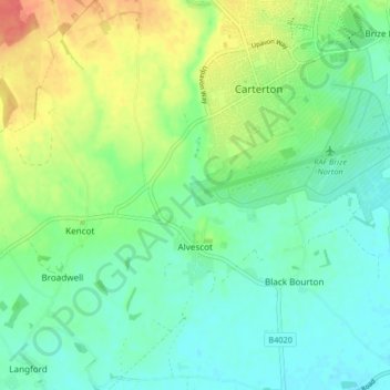
Name: Alvescot topographic map, elevation, terrain.
Average elevation: 87 m
Minimum elevation: 70 m
Maximum elevation: 121 m
Other topographic maps
Click on a map to view its topography, its elevation and its terrain.
Lew
United Kingdom > England > Oxfordshire > West Oxfordshire
Lew, West Oxfordshire, Oxfordshire, England, United Kingdom
Average elevation: 79 m
Ramsden
United Kingdom > England > Oxfordshire > West Oxfordshire
Ramsden, West Oxfordshire, Oxfordshire, England, United Kingdom
Average elevation: 136 m
Cassington
United Kingdom > England > Oxfordshire > West Oxfordshire > Cassington
Cassington, West Oxfordshire, Oxfordshire, England, United Kingdom
Average elevation: 72 m
Mount Skippett
United Kingdom > England > Oxfordshire > West Oxfordshire > Ramsden
Mount Skippett, Ramsden, West Oxfordshire, Oxfordshire, England, OX7 3AP, United Kingdom
Average elevation: 135 m
Standlake
United Kingdom > England > Oxfordshire > West Oxfordshire
Standlake, West Oxfordshire, Oxfordshire, England, United Kingdom
Average elevation: 67 m
Shipton-under-Wychwood
United Kingdom > England > Oxfordshire > West Oxfordshire
Shipton-under-Wychwood, West Oxfordshire, Oxfordshire, England, OX7 6DE, United Kingdom
Average elevation: 131 m
Chadlington
United Kingdom > England > Oxfordshire > West Oxfordshire
Chadlington, West Oxfordshire, Oxfordshire, England, United Kingdom
Average elevation: 161 m
Windrush
United Kingdom > England > Oxfordshire > West Oxfordshire > Witney
Windrush, Witney, West Oxfordshire, Oxfordshire, South East England, England, OX28 4DG, United Kingdom
Average elevation: 87 m
Burford
United Kingdom > England > Oxfordshire > West Oxfordshire > Fulbrook
Burford, Fulbrook, West Oxfordshire, Oxfordshire, England, United Kingdom
Average elevation: 129 m
Woodstock
United Kingdom > England > Oxfordshire > West Oxfordshire > Woodstock
Woodstock, West Oxfordshire, Oxfordshire, South East England, England, United Kingdom
Average elevation: 96 m
Brize Norton
United Kingdom > England > Oxfordshire > West Oxfordshire
Brize Norton, West Oxfordshire, Oxfordshire, England, United Kingdom
Average elevation: 97 m
Enstone
United Kingdom > England > Oxfordshire > West Oxfordshire
Enstone, West Oxfordshire, Oxfordshire, England, United Kingdom
Average elevation: 160 m
Chipping Norton
United Kingdom > England > Oxfordshire > West Oxfordshire > Chipping Norton
Chipping Norton, West Oxfordshire, Oxfordshire, England, United Kingdom
Average elevation: 194 m
Stanton Harcourt
United Kingdom > England > Oxfordshire > West Oxfordshire > Stanton Harcourt
Stanton Harcourt, West Oxfordshire, Oxfordshire, England, United Kingdom
Average elevation: 67 m
Kingham
United Kingdom > England > Oxfordshire > West Oxfordshire
Kingham, West Oxfordshire, Oxfordshire, England, United Kingdom
Average elevation: 130 m
Eynsham
United Kingdom > England > Oxfordshire > West Oxfordshire
Eynsham, West Oxfordshire, Oxfordshire, England, United Kingdom
Average elevation: 75 m
Lyneham
United Kingdom > England > Oxfordshire > West Oxfordshire
Lyneham, West Oxfordshire, Oxfordshire, England, United Kingdom
Average elevation: 130 m
Witney
United Kingdom > England > Oxfordshire > West Oxfordshire
Witney, West Oxfordshire, Oxfordshire, England, United Kingdom
Average elevation: 92 m
Taynton
United Kingdom > England > Oxfordshire > West Oxfordshire
Taynton, West Oxfordshire, Oxfordshire, England, United Kingdom
Average elevation: 152 m
Wilcote
United Kingdom > England > Oxfordshire > West Oxfordshire
Wilcote, North Leigh, West Oxfordshire, Oxfordshire, England, OX7 3EB, United Kingdom
Average elevation: 117 m