
Thank you for supporting this site ❤️
Make a donation
Make a donation
Murches topographic map
Click on the map to display elevation.
Thank you for supporting this site ❤️
Make a donation
Make a donation
About this map
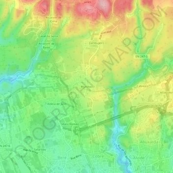
Name: Murches topographic map, elevation, terrain.
Location: Murches, Alcabideche, Cascais, Lisboa, 2755-237, Portugal (38.71189 -9.45955 38.75189 -9.41955)
Average elevation: 92 m
Minimum elevation: 21 m
Maximum elevation: 188 m
Thank you for supporting this site ❤️
Make a donation
Make a donation
Other topographic maps
Click on a map to view its topography, its elevation and its terrain.
Thank you for supporting this site ❤️
Make a donation
Make a donation
Thank you for supporting this site ❤️
Make a donation
Make a donation
Thank you for supporting this site ❤️
Make a donation
Make a donation