
Thank you for supporting this site ❤️
Make a donation
Make a donation
Union Dale topographic map
Click on the map to display elevation.
Thank you for supporting this site ❤️
Make a donation
Make a donation
About this map
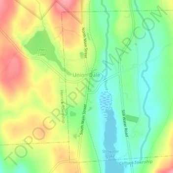
Name: Union Dale topographic map, elevation, terrain.
Location: Union Dale, Susquehanna County, Pennsylvania, United States (41.70307 -75.49764 41.72702 -75.46612)
Average elevation: 521 m
Minimum elevation: 475 m
Maximum elevation: 579 m
Thank you for supporting this site ❤️
Make a donation
Make a donation
Other topographic maps
Click on a map to view its topography, its elevation and its terrain.
Heart Lake
United States > Pennsylvania > Susquehanna County > Bridgewater Township
Average elevation: 482 m
Thank you for supporting this site ❤️
Make a donation
Make a donation
Lake Erie
United States > Pennsylvania > Susquehanna County > Clifford Township
Average elevation: 517 m
Thank you for supporting this site ❤️
Make a donation
Make a donation
Thank you for supporting this site ❤️
Make a donation
Make a donation