
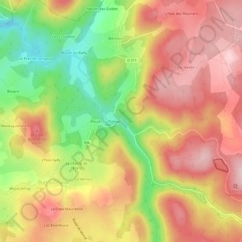
Le Montal topographic map
Interactive map
Click on the map to display elevation.
About this map
Name: Le Montal topographic map, elevation, terrain.
Average elevation: 529 m
Minimum elevation: 383 m
Maximum elevation: 638 m
Other topographic maps
Click on a map to view its topography, its elevation and its terrain.
Bornoux
France > Bourgogne-Franche-Comté > Nièvre > Dun-les-Places > Bornoux
Bornoux, Dun-les-Places, Château-Chinon (Ville), Nièvre, Bourgogne-Franche-Comté, France métropolitaine, 58230, France
Average elevation: 533 m
L'Huis Gally
France > Bourgogne-Franche-Comté > Nièvre > Dun-les-Places
L'Huis Gally, Dun-les-Places, Château-Chinon (Ville), Nièvre, Bourgogne-Franche-Comté, France métropolitaine, 58230, France
Average elevation: 503 m
Bonaré
France > Bourgogne-Franche-Comté > Nièvre > Dun-les-Places
Bonaré, Dun-les-Places, Château-Chinon (Ville), Nièvre, Bourgogne-Franche-Comté, France métropolitaine, 58230, France
Average elevation: 482 m
Le Breuil
France > Bourgogne-Franche-Comté > Nièvre > Dun-les-Places
Le Breuil, Dun-les-Places, Château-Chinon (Ville), Nièvre, Bourgogne-Franche-Comté, France métropolitaine, 58230, France
Average elevation: 584 m
Chalet du Breuil
France > Bourgogne-Franche-Comté > Nièvre > Dun-les-Places > La Bertoux
Chalet du Breuil, D 6, La Bertoux, Dun-les-Places, Château-Chinon (Ville), Nièvre, Bourgogne-Franche-Comté, France métropolitaine, 58230, France
Average elevation: 579 m
L'Huis des Meuniers
France > Bourgogne-Franche-Comté > Nièvre > Dun-les-Places
L'Huis des Meuniers, Dun-les-Places, Château-Chinon (Ville), Nièvre, Bourgogne-Franche-Comté, France métropolitaine, 58230, France
Average elevation: 562 m
Le Vieux Dun
France > Bourgogne-Franche-Comté > Nièvre > Dun-les-Places > Le Vieux Dun
Le Vieux Dun, Dun-les-Places, Château-Chinon (Ville), Nièvre, Bourgogne-Franche-Comté, France métropolitaine, 58230, France
Average elevation: 495 m