
Thank you for supporting this site ❤️
Make a donation
Make a donation
Eustis topographic map
Click on the map to display elevation.
Thank you for supporting this site ❤️
Make a donation
Make a donation
About this map
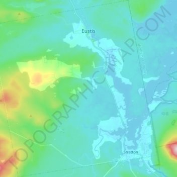
Name: Eustis topographic map, elevation, terrain.
Location: Eustis, Franklin County, Maine, United States (45.12545 -70.56638 45.23660 -70.41723)
Average elevation: 413 m
Minimum elevation: 344 m
Maximum elevation: 819 m
Thank you for supporting this site ❤️
Make a donation
Make a donation
Other topographic maps
Click on a map to view its topography, its elevation and its terrain.
Thank you for supporting this site ❤️
Make a donation
Make a donation
Sandy River Plantation
United States > Maine > Franklin County > Sandy River Plantation
Average elevation: 589 m
Height of Land Scenic Overlook
United States > Maine > Franklin County > Township D > Rangeley Plantation
Average elevation: 601 m
Thank you for supporting this site ❤️
Make a donation
Make a donation