
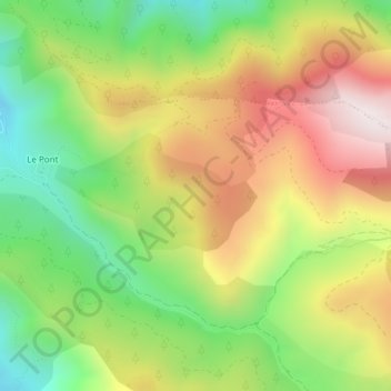
Les Vergères et Combe d'Hier topographic map
Interactive map
Click on the map to display elevation.
About this map
Name: Les Vergères et Combe d'Hier topographic map, elevation, terrain.
Average elevation: 1,462 m
Minimum elevation: 1,127 m
Maximum elevation: 1,846 m
Other topographic maps
Click on a map to view its topography, its elevation and its terrain.
Baudinard
France > Provence-Alpes-Côte d'Azur > Alpes-de-Haute-Provence > Bayons
Baudinard, Esparron-la-Bâtie, Bayons, Forcalquier, Alpes-de-Haute-Provence, Provence-Alpes-Côte d'Azur, France métropolitaine, 04250, France
Average elevation: 1,324 m
Reynier
France > Provence-Alpes-Côte d'Azur > Alpes-de-Haute-Provence > Bayons
Reynier, Bayons, Forcalquier, Alpes-de-Haute-Provence, Provence-Alpes-Côte d'Azur, France métropolitaine, 04250, France
Average elevation: 1,234 m
Esparron-la-Bâtie
France > Provence-Alpes-Côte d'Azur > Alpes-de-Haute-Provence > Bayons
Esparron-la-Bâtie, Bayons, Forcalquier, Alpes-de-Haute-Provence, Provence-Alpes-Côte d'Azur, France métropolitaine, 04250, France
Average elevation: 1,422 m