
Make a donation
Berndorf topographic map
Click on the map to display elevation.
Make a donation
About this map
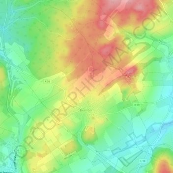
Name: Berndorf topographic map, elevation, terrain.
Average elevation: 487 m
Minimum elevation: 430 m
Maximum elevation: 558 m
Make a donation
Other topographic maps
Click on a map to view its topography, its elevation and its terrain.
Pulvermaar
Deutschland > Rheinland-Pfalz > Landkreis Vulkaneifel > Gillenfeld
Das nahezu kreisrunde Maar hat steile trichterförmige Wände. Der Wasserspiegel des Maarsees liegt auf einer Höhe von 411 m ü. NHN; mit einer maximalen Wassertiefe von 72 m ist er der tiefste See der Vulkaneifel. Bei einem Durchmesser von knapp 700 m beträgt die Seefläche etwa 38,48 ha und ist damit nach…
Average elevation: 428 m
Dauner Maare
Deutschland > Rheinland-Pfalz > Landkreis Vulkaneifel > Schalkenmehren
Average elevation: 468 m
Make a donation
Make a donation
Jünkerather Schloss "Glaadter Burg"
Deutschland > Rheinland-Pfalz > Landkreis Vulkaneifel > Glaadt
Average elevation: 495 m
Make a donation
Burg Daun
Deutschland > Rheinland-Pfalz > Landkreis Vulkaneifel > Daun
Die Burg Daun ist die Ruine einer Höhenburg in der Vulkaneifel. Sie war Stammburg der Herren zu Daun, zu Oberstein an der Nahe, zu Densborn bei Gerolstein, zu Bruch bei Wittlich und Zievel bei Euskirchen. Vor der Zeit der Dauner Herren und späteren Grafen war der Basalthügel vermutlich eine keltische…
Average elevation: 441 m
Make a donation
Vulkanfeld Westeifel
Deutschland > Rheinland-Pfalz > Landkreis Vulkaneifel > Schalkenmehren
Average elevation: 467 m
Hinterhausen
Deutschland > Rheinland-Pfalz > Landkreis Vulkaneifel > Gerolstein
Average elevation: 455 m
Make a donation
Hochkelberg
Deutschland > Rheinland-Pfalz > Landkreis Vulkaneifel > Kelberg
Der Hochkelberg im Landkreis Vulkaneifel (Rheinland-Pfalz) ist mit 674,9 m ü. NHN Höhe der dritthöchste Berg der Hocheifel.
Average elevation: 547 m
Obere Kyll und Kalkmulden der Nordeifel
Deutschland > Rheinland-Pfalz > Landkreis Vulkaneifel > Wiesbaum
Average elevation: 497 m
Weinfelder Maar
Deutschland > Rheinland-Pfalz > Landkreis Vulkaneifel > Schalkenmehren
Der Maarsee entstand vor rund 30.000 Jahren bei einer vulkanischen Dampfexplosion und ist rund 525 m lang, 375 m breit und 51 m tief. Die Wasserfläche beträgt bei einem Umfang von 1.525 m etwa 16,8 ha. Das Maar liegt auf einer Höhe von 483,5 m ü. NHN. Der aus Tuff bestehende, den See umgebende Wall ist an…
Average elevation: 467 m
Make a donation
Dürres Maar
Deutschland > Rheinland-Pfalz > Landkreis Vulkaneifel > Gillenfeld
Average elevation: 447 m
Trautzberger Maar
Deutschland > Rheinland-Pfalz > Landkreis Vulkaneifel > Strohn > Trautzberg
Average elevation: 400 m
Gemündener Maar
Deutschland > Rheinland-Pfalz > Landkreis Vulkaneifel > Schalkenmehren
Average elevation: 447 m
Make a donation
Ernstberg
Deutschland > Rheinland-Pfalz > Landkreis Vulkaneifel > Hinterweiler
Im Winter bestehen am Ernstberg bedingt durch die Höhenlage oft gute Wintersportmöglichkeiten. Gespurte Langlauf-Loipen, Rodelhang und Hütte mit Skiverleih sind vorhanden.
Average elevation: 586 m
Kronenburger See
Deutschland > Rheinland-Pfalz > Landkreis Vulkaneifel > Hallschlag
Average elevation: 554 m
Make a donation
Eifelblick "Auf Heilert"
Deutschland > Rheinland-Pfalz > Landkreis Vulkaneifel > Duppach
Average elevation: 566 m
Dauner Maare
Deutschland > Rheinland-Pfalz > Landkreis Vulkaneifel > Schalkenmehren
Average elevation: 468 m
Make a donation
Hinterhausen
Deutschland > Rheinland-Pfalz > Landkreis Vulkaneifel > Gerolstein
Average elevation: 455 m