
Lewis County topographic map
Interactive map
Click on the map to display elevation.
About this map
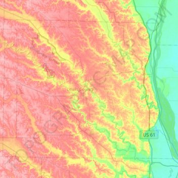
Name: Lewis County topographic map, elevation, terrain.
Location: Lewis County, Missouri, Vereinigte Staaten von Amerika (39.94803 -91.95487 40.25885 -91.43836)
Average elevation: 189 m
Minimum elevation: 141 m
Maximum elevation: 231 m
Other topographic maps
Click on a map to view its topography, its elevation and its terrain.
Norvey Creek
Vereinigte Staaten von Amerika > Missouri > Nodaway County
Norvey Creek, Nodaway County, Missouri, 64476, Vereinigte Staaten von Amerika
Average elevation: 343 m
Iron County
Vereinigte Staaten von Amerika > Missouri
Iron County, Missouri, Vereinigte Staaten von Amerika
Average elevation: 292 m
Shannon County
Vereinigte Staaten von Amerika > Missouri
Shannon County, Missouri, Vereinigte Staaten von Amerika
Average elevation: 308 m