
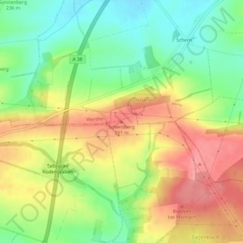
Schernberg topographic map
Interactive map
Click on the map to display elevation.
About this map
Name: Schernberg topographic map, elevation, terrain.
Average elevation: 252 m
Minimum elevation: 205 m
Maximum elevation: 302 m
Other topographic maps
Click on a map to view its topography, its elevation and its terrain.
Wöbelsburg
Deutschland > Thüringen > Landkreis Nordhausen > Bleicherode
Wöbelsburg, Bleicherode, Landkreis Nordhausen, Thüringen, Deutschland
Average elevation: 321 m
Friedrichsthal
Deutschland > Thüringen > Landkreis Nordhausen > Bleicherode > Friedrichsthal
Friedrichsthal, Bleicherode, Landkreis Nordhausen, Thüringen, Deutschland
Average elevation: 244 m